
Peter Albinger / Canada
From Peter Albinger / Canada
Santa Cruz Trek & Pisco Climb 2007
For the full story and lots more great photos, clic onto the link to Peters Web:
http://albinger.me/2012/04/27/getting-higher-in-perus-cordillera-blanca
Getting Higher in Peru’s Cordillera Blanca
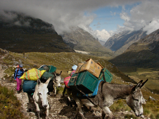
arriero and donkeys approaching Punta Union pass with the Quebrada Santa Cruz below
One evening I was in Cuzco unpacking my Machu Picchu stuff and getting ready for the flight to Lima the next morning; twenty-four hours later I was at Olaza’s Bed and Breakfast in Huaraz, a town which serves as the main access point for trekkers and climbers heading into the Cordillera Blanca. Most of the day had been spent on the Movil Tours bus from Lima- eight hours and 440 or so kilometres along the desert coast and then up into the mountains.
Olaza’s proved to be a great place to stay in this town of 45,000- just a short walk from the downtown area and providing all the services you could want (laundry, kept luggage, and a great breakfast spot on the rooftop patio).
[A brief note- Huaraz is not a pretty town. In May of 1970 most of the city was destroyed and a half of the town’s population was dead after a 7.7 earthquake shook the entire region. Down the valley the town of Yungay was completely buried by the accompanying landslide. What it lacks in beautiful old buildings, however, Huaraz more than makes up with its open and dynamic street life. Finding great places to eat is never a problem in Huaraz!]
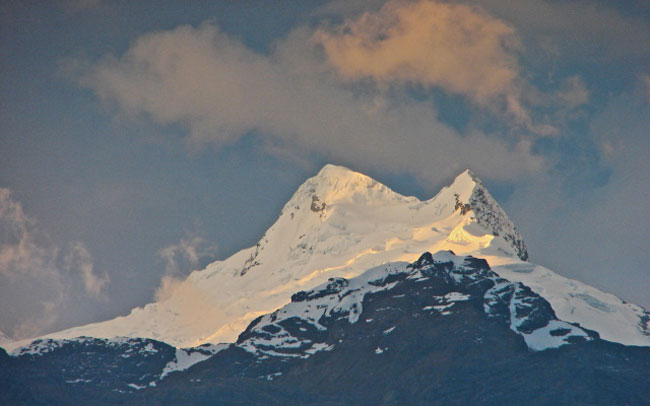
looking into the Cordillera Blanca from the Olaza rooftop and seeing just one of the dozens of 5500 meter peaks- next to the Himalayas, it is the most impressive rock collection in the world!
I had two weeks to spend in the Parque Nacional Huascaran, which contains all of the Cordillera Blanca over 4000 meters in altitude. After a 40-kilometer hike up the Quebrada Santa Cruz and a summit attempt of Nevado Pisco (5752 m), the plan was to go up the Ishinca valley and climb Nevados Ishinca (5530 m) and- if all went well- Tocllaraju (6034 m). I hoped to earn (or is that to be granted?) my first 20,000 feet + peak by the end of the trip!
As I mentioned in Getting Real High in the Peruvian Andes, I used the services of Peruvian Andes Adventures and consider myself lucky to have picked them. If there are another half-dozen trekking outfits in Huaraz like this one run by the Morales family, then international trekkers are indeed well-served!
Since I had spent a week in the Cuzco region, I already had some acclimatization under my belt. This meant that we could start the Santa Cruz trek earlier than if I had just arrived from Toronto via Lima.
On May 20 we drove north down the Callejon de Huaylas (the valley between the Cordillera Negra and the Cordillera Blanca down which the Rio Santa flows). After a quick breakfast stop in a Caraz restaurant overlooking the Plaza de Armas, it was off to Cashapampa to meet our arriero and his four burros; they’d be carrying the camp gear and most of our personal stuff. There were only two clients in the party- a Montreal adventurer in his mid- 20′s and me in my mid-50′s. To make it all happen we had Cesar Vargas, the guide; Cesar Henostrosa, the cook and assistant guide, as well as the Quechua arriero and his animals.
We had hoped that one or more trekkers would join the group- and bring down the per-person cost!- but it was not to be. We were amongst the first trekkers of the season- had we left in late June or July it would have been much easier to add an extra person or two. All in all, it was still a relative bargain. You can of course do the trek by yourself and spend even less but I will admit that it is a treat to walk with just a day pack on your back instead of everything, including your accommodation and cook gear and four or five days of food.
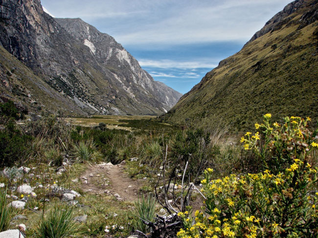
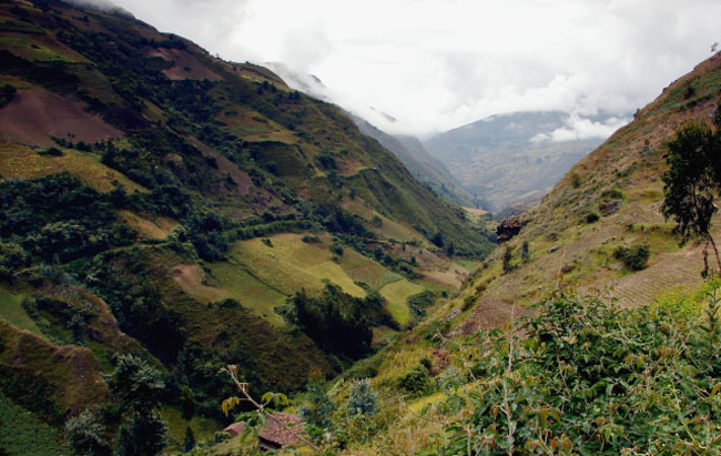
Cashapampa, the start point of the trek, sits at 2800 meters; the goal for the first day was to hike up the canyon to Llamacorral (3750m), where we would set up our camp in the meadow. The Rio Santa Cruz is never far away as you walk the trail and there is a closed-in feel to the first few kilometres-
on the first stretch of the Santa Cruz hike the trail follows the Rio Santa Cruz on the right
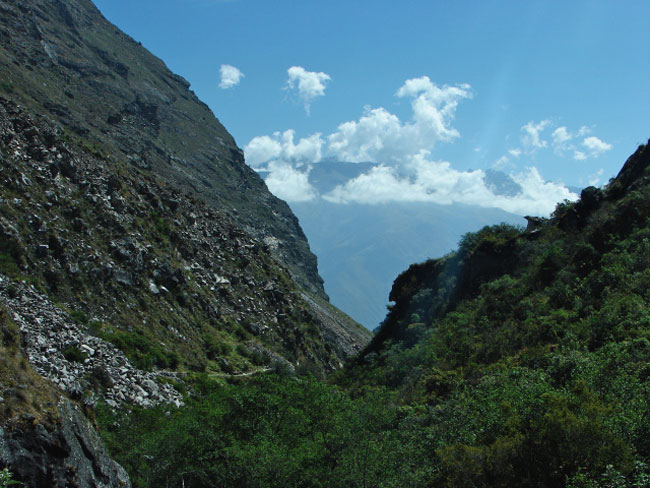
narrow passage of the trail up the Santa Cruz valley- in early 2012 a landslide in this area blocked the way and the trail was closed while park workers cleared the rubble
After about four hours of walking we are at Llamacorral and set up camp. The donkeys get to take it easy until the next morning and forage for anything green to nibble on.
We each had our own two-man mountaineering tent; there was also a cook/dining tent and a toilet tent set up by the crew. They were already up when we walked up to Llamacorral in the late afternoon, with the sun’s warmth already gone because of the steep walls of the mountains.

tents at Llamacorral in the Quebrada Santa Cruz- the blue one on the right was the cook/dining tent
Things opened up on the second day as we made our way up to Taullipampa with a early afternoon side trip which took us towards Alpamayo Base Camp and gave us some great views of the peak and of the valley below.
approaching Laguna Jatuncocha in the morning of Day Two on the morning of Day Two
Quebrada Santa Cruz above Laguna Jatuncocha

the view of Alpamayo from the side trail from the Quebrada Santa Cruz
We camped at Taullapampa (4250m) at the end of Day Two. Sometimes during the night the donkeys decided to go back home to Cashapampa so we ended up spending an extra day here while the arriero fetched them! We took the opportunity for a bit of extra acclimatization and climbed to the top of a 5000 m peak called Sentillo on the south side of the valley and were rewarded with fantastic views.
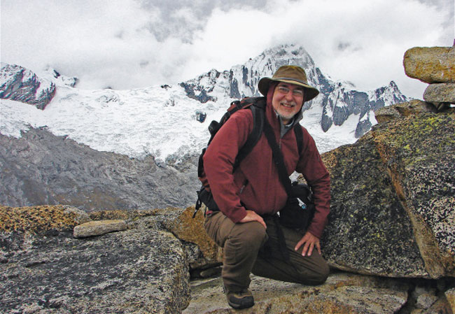
me posing on the top of Sentillo above the Santa Cruz valley with the peak of Nevado Taulluraju providing a crown!
And here is our camp site at Taullapampa about 800 m below from the top of Sentillo – From our Sentillo vantage point we could clearly see the next bit of our hike. In the image below you can see the trail zig zag its way from the bottom middle all the way up to a point on the ridge. That point would be Punta Union, the high point of the actual trek at 4750m.
Back down on the valley floor the view was a bit different! Here is a shot of Taulluraju with the laguna itself hidden from sight-
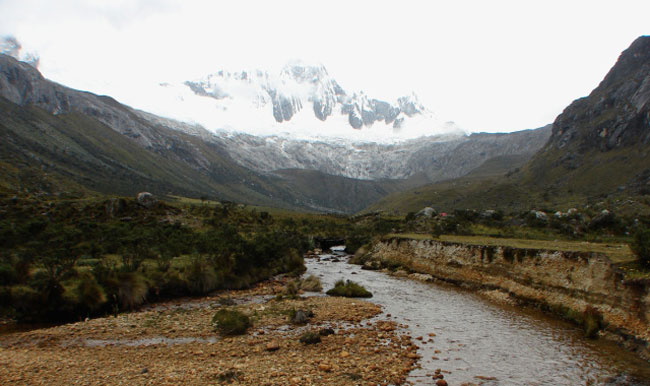
Rio Santa Cruz with Nevado Taulluraju in the background and our tent site in the middle right
the Rio Santa Cruz flowing towards Cashapampa from Taullipampa
On Day Four we left the Quebrada Santa Cruz via the pass at Punta Union and walked down the slopes to the Hauripampa Valley. Following this valley would take us to the end point Vaqueria, where a vehicle would pick us up the next morning. But first, more stunning views
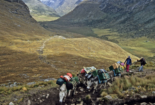
our four burros heading up to Punta Union pass with all the gear- the arriver and Cesar Vargas, the guide, follow behind

a last look back at Nevado Taulluraju from Punta Union
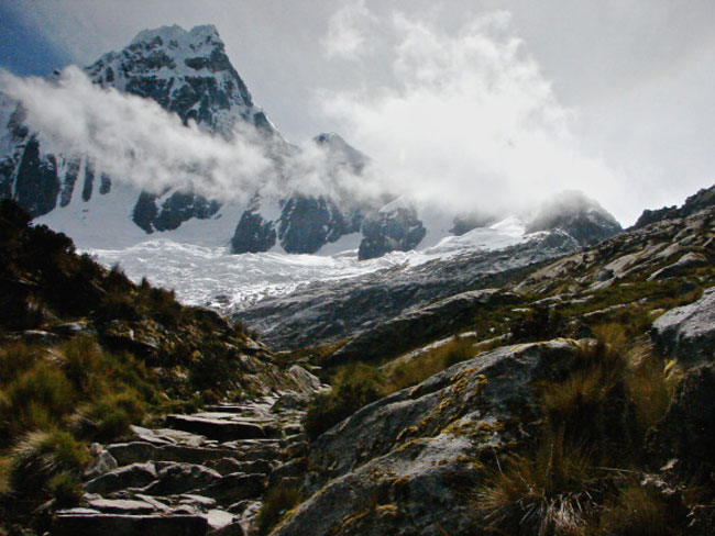
a section of the trail just below Punta Union

Punta Union with Quebrada Santa Cruz down below- you can see Laguna Jatuncocha down the valley
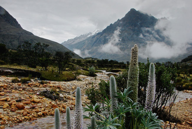
And then it is down to a new valley! Along the way the trail passes a few small lakes like this one
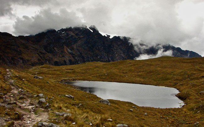
Laguna below Punta Union on Huaripampa side
Cesar el cucinero has as always raced ahead of us so by the time we pass the small laguna we see him up ahead in a meadow with the lunch spread all ready for us. All I can say is if you have Cesar as your camp cook you just know that you will eat well-
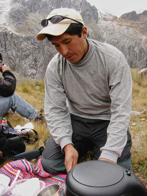
Cesar at the lunch stop below the pass at Punta Union
Eventually we walked pass the camping area at Paria but did not camp there; instead, we camped just a bit further down the valley
The vegetation was becoming more and more lush as we lost altitude; soon we were walking through stands of quenua – Signs that we were not far from people and small settlements started popping up. The sight of grazing sheep became more common-
I was surprised to see two children- a brother and sister- on their way to school the next morning. I did a tourist no-no and reached into my pocket for the candies that Cesar had included with the day’s snack pack and offered them to the kids. They took them shyly and- having put the candies away!- continued on their path.

two Quechua children stare into the lens of the candy-giving gringo
the trail cuts across the hillside with cultivated patches of land clearly visible And then a sign that we were not far from the end of our Santa Cruz hike
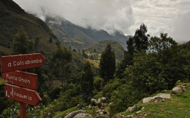
Vaqueria- the end point- this way!
After a bit of uphill to get out of the valley, we are standing by the side of Route 106, the road that will take us over the Portacuelo Pass and, after a four-day climbing trip to Nevado Pisco, back to the main highway and Huaraz. (See the map at the start of this post for the total picture!)
Our wait for the transfer vehicle from Huaraz would not be long; it was perhaps 45 minutes after we arrived that it pulled up, with plenty of room for our gear as well as with new supplies for the 3 1/2 days we’d be climbing Pisco.
We also gave a ride to a Swedish hiker who became my new climbing partner when the young Montrealer bailed out because of a bad cold/flu and she bought in on the climbing part of the trip.
The ride one the pass and down to the trailhead to Pisco was stunning. Portacuelo Pass sits at 4850m and from there you can look way west past the Llanganuco Lagunas. These following images will show it better than my words can tell!
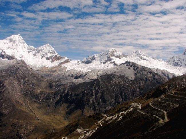
looking down the switchbacks to the bottom of the valley and then through Cebollapampa up towards Refugio Peru and our climbing objective, Nevado Pisco, the third peak from the left
the two Llanganuco lakes sit below us as we take in the view near the top of Portacuelo Pass- Route 106 to Yungay continues on the right hand side of the lakes
As we looked north towards Pisco, Cesar the guide explained how it would all unfold. We would get to our base camp by mid-afternoon this day; the next day we would move up to the Moraine Camp- sort of on the bottom left hand corner of the following image; finally on the third day we would make a very early (2:00 a.m.) start from the Moraine Camp and be on top of Pisco by nine or ten o’clock. Here again is the terrain to be covered.
Pisco is not a technical climb but the proper gear and the right attitude is still required; it is also a fact that global warming is changing the faces of the glaciers throughout the Andes and Pisco is no exception. What the guides once knew is disappearing; what is appearing-i.e. objective hazards like crevasses- is unknown and must be treated with caution. Given that my concept of literacy involves reading black marks on paper or screen, I am always happy to be in the hands of a capable guide like Cesar Vargas, who has spent a lifetime in the mountains and has developed the literacy skills necessary to read the snow and rock that we move across.
Our first Pisco day had a simple objective- get up to the meadow below Pisco and below the Refugio Peru. It involved walking through Cebollapampa and then up a clearly-defined trail to our camp site. Amazingly, when we got there we were the only climbing party tenting! It was May 24; I guess we were a bit early in the season. Apparently during prime time in July and August the meadow is jammed with tents. I’m glad I missed it!
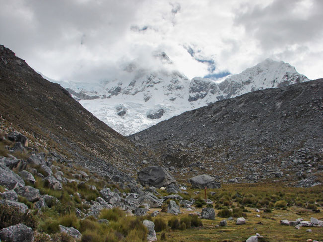
the meadow which would serve as base camp for our summit of Pisco a day and a half later
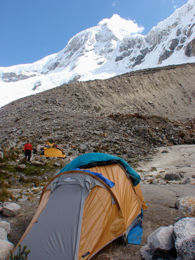
airing out my goose down bag for a while before it is time to pack for the trip to Moraine Camp
After lunch we broke camp and, with Tony as our porter to carry some extra gear, made our way to the Moraine Camp at 4900m, a three-hour climb over the moraine and scree fields. By 4:30 we were there and looking back:
I don’t have any pix from the time we crawled into our sleeping bags to after sunrise as we made our way up the side of Pisco. The idea behind the early start is to get the snow while it is at its coldest and hardest; ideally you should be coming down from your summit by eight or nine in the morning without sinking knee-deep into the soft snow with each step you take.

no new snowfall means a clearly visible path leads up to the top
Once the sun came out it was actually pretty warm; I stripped down to my base layer and a thin soft shell. We were roped up from the moment we stepped onto the snow until we returned to the scree after our descent.
And then we were there- WOW! High fives all around. Taking in stupendous views. Sunday morning and people are going to church and I am thinking- This is my church! This is where I acknowledge my gratitude for being alive, for being a part of it all.
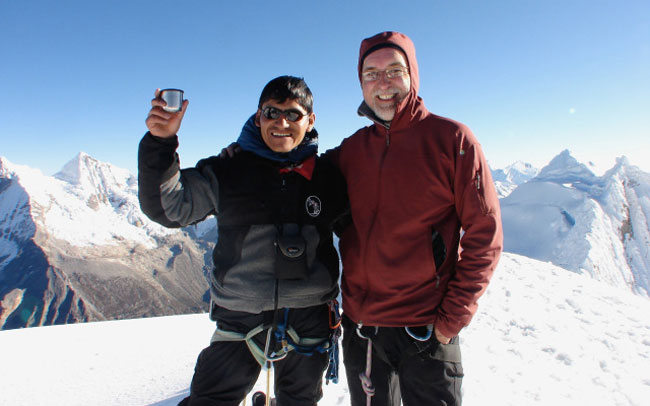
Cesar Vargas and I on Pisco summit- it always feels great to meet the challenge and succeed
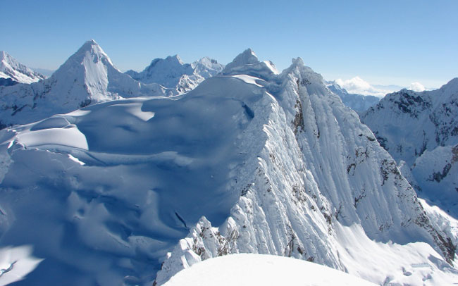
incredible views all around you
After a glorious chunk of time up on the summit- fuelling up, relaxing, taking snapshots, enjoying the sun’s warmth and having Cesar name the various peaks yet again, socializing with a party of six Brits that came up a few minutes later- it was time to go back down. Our porter Tony had already dismantled camp and gone down with most of the stuff, so it would not take too long to get back to the base camp in the pasture below the Refugio Peru.
We now got to see the crevasses and other potential problem spots that we had walked by in the dark on the way up.
The Brits were good enough to pose on the summit as I pointed my camera up at them.
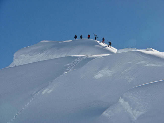
climbers on Pisco summit celebrate their place in the world!
Finally that moment where we make the transition from mountaineering to hiking! We untied the rope from our harnesses, took off the crampons and the harnesses, and got ready for the quick descent to base camp.
A quick stop at the Moraine Camp to pick up the rest of the gear and we were good to go!
Cesar the cook had a light lunch ready for us when we arrived- lots of soup and some pasta concoction that filled us up. Given that we hadn’t really slept that much the night before it was time for a mid-afternoon nap. here is the view from my Macpac tent just before the fly was zipped shut-
The rest of the this day was spent relaxing and eating and reminiscing- and talking a little about the next instalment of our Peruvian Andes adventure, our upcoming visit to the Quebrada Ishinca and the peaks we would do there.
The next morning we had a easy walk down to Cebollapampa and the road (Route 106) which would take us past the Lagunas Llanganuco and back up the valley to Huaraz.

we walked through Cibollapampa on our way back to the rendezvous point on the side of Route 106
Some parties camp at Cebollapampa before making the ascent up to the plateau below the Refugio Peru or while waiting for vehicles to arrive the next day. We were just passing through.
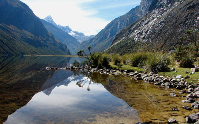
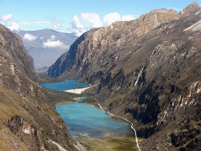
A bonus for us was some time spent along the shores of the two Llanganuco lakes on the way back to Highway 5N.
One more shot and we’ll put this post to rest! We are on the rooftop patio of Olaza’s Bed and Breakfast enjoying the brief respite before we take off again- a Swede, a Quebecois and a Torontonian sharing a common interest and hanging out in Huaraz, Peru!
Some Useful Links:
A site in need of being updated but still useful as an inspirational first step in planning your Santa Cruz hike (or any hike!) is best hikes.com. You’ll find a point-form approach which dishes out lots of still-relevant info on hiking possibilities in the central Andes as well as specific details on individual hikes, like the Santa Cruz trek. It would be great to see these pages brought into the present from their current early 2000′s state.
You can buy individual chapters in digital form of the Lonely Planet’s Peru for upload to your iPad or smartphone.
The chapter on Huaraz and the Cordilleras goes for $4.95. or you can buy the whole book for not that much more.
The Lonely Planet website also has an active forum with some members very generously sharing their vast experience. Check out this link for posts over the past three years specifically on the Santa Cruz trek.
Peruvian Andes Adventures is not the only outfitter/guide service in Huaraz who can make your trip happen for you- if fact, it is inexplicably not even mentioned in the Lonely Planet book on Peru!- but if you want to see the hiking/climbing combo that I did with them, here is the link to Santa Cruz trek and Climbing Pisco. If you check out their site you will notice that they even facilitate the connecting of hikers looking for partners to make trips possible- and cheaper! Look here.
Huaraz has lots of reasonably-priced accommodation for visiting hikers and climbers. On this trip I stayed at Olaza’s Bed and Breakfast and was 100% pleased with my stay. During my second visit to Peru in 2010 to do the Cordillera Huayhuash Circuit (also with Peruvian Andes Adventures) , I stayed at the Morales Guesthouse. It too proved to be a convenient base for my three weeks there. Amazingly the area of town where it is located managed to escape the devastation of the 1970 earthquake- so you’ll be walking the quaint colonial streets nearby